Come with me and see something wonderful and sad.
I was just re-reading one of my favorite passages from H.V. Morton's In Search of England, close to the beginning when he enters Cornwall.
"I had no idea where to make for in Cornwall. One road was as good as another. I took the map and one name curled itself round my heart. I do not think that in the whole length and breadth of England there is a more beautiful name. But to fall in love with a name is like falling in love with a voice heard over the telephone. A meeting might prove fatal. But not to risk the...impossible. I whispered it twice, and took the inevitable road to : St. Anthony in Roseland."
* ~ * ~ *
Roseland.
It is a peninsula in Cornwall and looks like one of the lovliest places in the world. Reminds me of...somewhere.

"The parish is named after St Anthony. The Roseland is thought to mean "the land of the promentory" Rhos being the old Cornish for 'Headland'. The village is situated on the Roseland Peninsula to the east of the Carrick Roads and about 9 miles south-west of Tregony. It is not mentioned in the Domesday Book of 1086."
Wiki says:
The Sicilian Greek historian Diodorus Siculus (c.90 BC–c.30 BC), supposedly quoting or paraphrasing the fourth-century BC geographer Pytheas, who had sailed to Britain, said:The inhabitants of that part of Britain called Belerion (or Land's End) from their intercourse with foreign merchants, are civilised in their manner of life. They prepare the tin, working very carefully the earth in which it is produced…Here then the merchants buy the tin from the natives and carry it over to Gaul, and after travelling overland for about thirty days, they finally bring their loads on horses to the mouth of the Rhône.
St Anthony-in-Roseland Parish is in the Carrick district near to the mouth of the River Fal and the Carrick Roads. The area is a rocky peninsula of mainly farmland with a prominent lighthouse, built in 1835 and still operating, and a former gun battery on its South Western promontory. The main family which has been associated with this parish was SPRY. There are very few houses in this small parish.

I found it.


HV Morton continued on to find it too.
I am writing in the tiny bedroom of a cottage is St. Anthony in Roseland. The thatch comes down so low that the upper part of the window frame has a stubby beard. I can see when I look out of the window a clump of trees and a field shaped like a green dome; beyond is a vast emptiness of sky that means the sea. I cannot see the water, but I can hear a steady whisper of waves breaking in the little rocky bay below. That and the song of birds are the only sounds in St. Anthony in Roseland.
I have said that I came here because I liked the name. I came prepared for the worst: for a mine shapft and a street of dreary shops. At Tregoney I left the main road and dived in a labyrinth of lanes so small that there was no clearance between the car and the hedge-banks. Green plants caught me by the arm and seemed to say: 'Don't go on; don't go on; a man who expects St. Anthony in Roseland to look as it sounds is only gathering one more disappointment...'
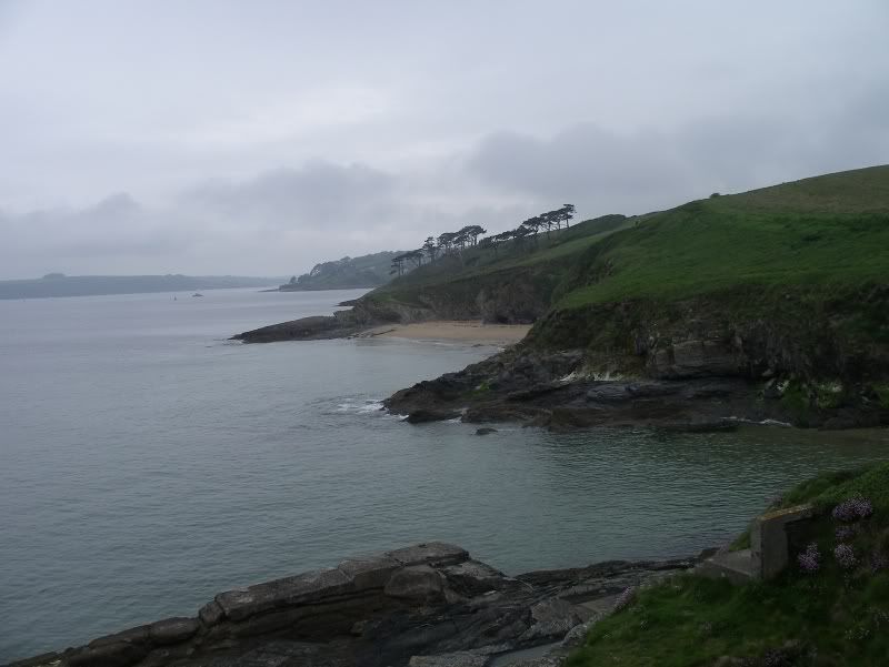
But I went on; and I came at length to the darkest tunnel of a lane I have ever seen. The hedges had grown up and formed arches the whole length of it; and the lane dipped down and down in green gloom and then rose steeply, in the manner of thse Cornish lanes, bending suddenly to give a view of the sea, startlingly near, breaking on a rocky coast, the high hills lying back spread with neat, cultivated fields. Turning a corner I came to St. Anthony in Roseland.

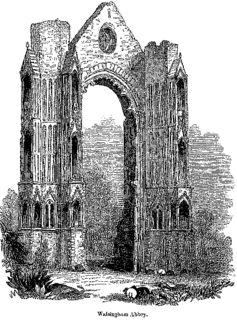
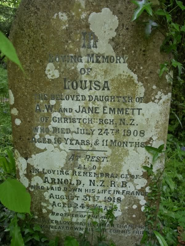
St. Anthony's Churchyard
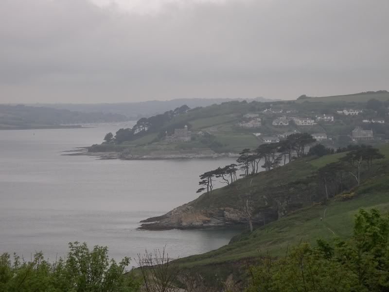
St Anthony's Head across to St Mawes Castle, built by Henry VIII between 1535 and 1545


Morton:
Now, if anything you have believed in has continued to be worth your faith, if anything you have wanted has not fallen below the expectation, you will realize my wonder when I saw St. Anthony.
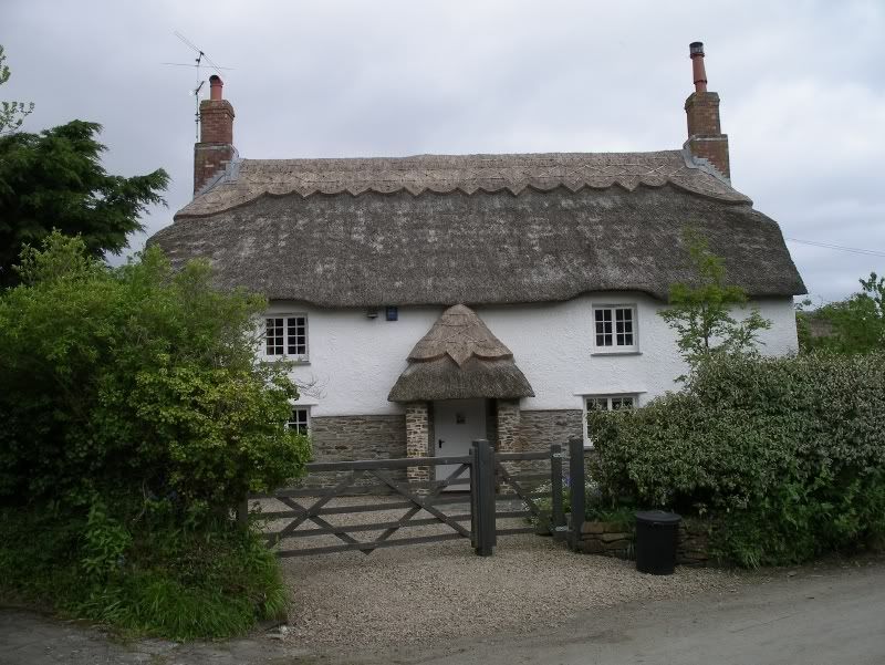
This cottage is in Treworthal, somewhat to the north of St. Anthony
Twenty tiny whitewashed cottages stood dotted about among tall hedges. They were covered with flowers. The bees were busy in the gardens...There was no inn, no post office, and the nearest shop, I learned, is at Gerrans, five miles down those lucious lanes. St Anthony in Roseland seemed lost, and happy to be lost, dreaming beside the sea.
There was no sign of life. The little white cottages covered with briar roses and ivy geraniums stood with doors open, yet no sign of man, woman or child. No one seemed to have heard me drive up. Not a sound!
I was a footpath over a field; below was a tiny bay, nestling between two gaunt cliffs.
St. Anthony's Head
There was no sign of life... I went back to the cottages.
A rosy middle-aged woman, wearing a print apron, was standing at the door of a pink cottage, looking at my car as though it were an unnatural phenomenon.
'I wonder,' I said, 'if you could tell me where I cold stay the night?'
A great bush of veronica was in bloom in the garden, the porch was smothered in geraniums, Canterbury bells stood beneath the windows, and hte paths were lined iwth London Pride.
'Well,' said the woman, 'I've got nothing for dinner, sir, but eggs and cream, because we have no shops, and everything is brought us from Gerrans in a motor car - or else I'd gladly give you my spare room.'
* ~ * ~ *
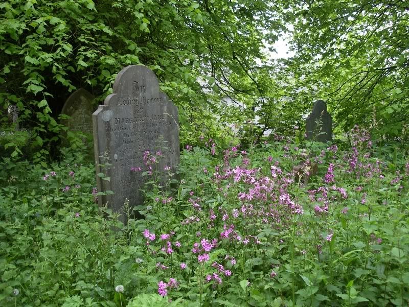
I discover that the parish of St Anthony has been part of Gerrans (five miles down the road) since 1934, only a few years after Morton visited. It was indeed going extinct. The church still exists and the churchyard is overgrown but "it's a beautifully peaceful place," according to a local historian.
* ~ * ~ *
Morton notes the absolute stillness and asks the question: why is St. Anthony in Roseland so quiet?
"'Well, you see sir, there are no children here now. We are all old. We closed the school years ago. As children grow up here they have to go away and do for themselves. My boy who was in the war, and my two girls are doing well. Some chidlren come back to the farms when their fathers die.'
So that is the secret of St. Anthony in Roseland. It has had its children, they have left the nest, and the old people stay on among the flowers. I looked outside and saw a tumble down shack, half cowshed, half chapel, its wood rotting and its beams falling in.
'Oh, that's the schoolroom. I can remember when it was full every morning; and hte noise and the chatter...'
Now the nettle and the foxglove seek the make a green pall for all that is left of youth in St. Anthony in Roseland..."
* ~ * ~ *
It was settled from earliest recorded times. Cornwall is the home of King Arthur and Tingagel is in the neighbourhood. The original inhabitants were Celts and the Cornish (Kernow) are considered among the five original Celtic nations. The Celtic tribes were pushed back to the westernmost parts of the islands by the invading Saxons. Later the Conquerer came and then Protestantism. It seems, however, that the Cornish culture still survives, though I fear that, as have so many other Real Places in England, it has been turned into a theme park of itself with the local inhabitants of ancient blood hired to play themselves for the tourists.
It seems that the people who had lived in St. Anthony's Parish in Roseland are all gone. The cottages still stand and are renovated and fitted out with the latest appliances in order to be rented out to holidaymakers from the cities.
A theme park of itself.
Update:
With the help of GoogleEarth, I have been able to pinpoint the exact coordinates for St. Anthony-in-Roseland parish church.
50° 8'32.53"N
5° 0'48.67"W
It's the closest I can figure out how to make a link to a GoogleEarth site.
I made a place mark (right on what looks like the East transept) and another one over our house (named "Our House"), and figured out how to make it into a Google Map.
Thus
That gives a direct route from Our House to the East Transept of St. Anthony-in-Roseland church. Which includes the following directions (which also helpfully includes estimated driving times...see especially step 21. Though I don't quite see, if we are swimming, why we need to dither about in France. Why not just swim right there? Maybe the tides are a bit dangerous on that coast. Depends on when you're planning on making the attempt, I suppose.):
1. Head west on King St W toward Close Ave 1.1 km 2 mins
2. Turn left at The Queensway 1.1 km 2 mins
3. Turn left at Colborne Lodge Dr 0.2 km 1 min
4. Turn right at Lake Shore Blvd W 1.1 km 2 mins
5. Take the ramp onto Gardiner Expy W 7.3 km 5 mins
6. Continue on QEW 101 km 1 hour 3 mins
7. Take exit 37 on the left for HWY-405 toward Queenston 0.4 km
8. Merge onto HWY-405 E 8.3 km 5 mins
9. Continue on Queenston-Lewiston Bridge 0.8 km
10. Continue on I-190 S Entering United States (New York) Partial toll road 23.8 km 17 mins
11. Take exit 16 to merge onto I-290 E/Youngmann Expy toward I90 Tonawanda Rochester 15.8 km 11 mins
12. Take exit 1-49 for I-90 E toward Albany 1.0 km 1 min
13. Merge onto New York State Thruway E Toll road 459 km 4 hours 25 mins
14. Take exit 21A toward I-90 E/Mass Turnpike/Boston Toll road 1.5 km 1 min
15. Merge onto New York State Thruway E Toll road 38.7 km 22 mins
16. Continue on I-90 E/Mass Pike/Massachusetts Turnpike Partial toll road Entering Massachusetts 216 km 2 hours 9 mins
17. Take exit 24 A-B-C on the left toward I-93 N/Concord NH/S Station/I-93 S/Quincy 0.7 km 1 min
18. Merge onto Atlantic Ave 1.2 km 3 mins
19. Turn right at Central St 0.2 km
20. Turn right at Long Wharf 0.2 km
21. Swim across the Atlantic Ocean 5,572 km 29 days 0 hours
22. Slight right at E05 0.8 km 2 mins
23. At the roundabout, take the 2nd exit onto E05/Pont Vauban 0.2 km
24. Turn right at E05 9.2 km 10 mins
25. Take the exit onto A29/E44 toward Amiens Toll road 44.7 km 23 mins
26. Take the exit toward Dieppe/Amiens/Calais/A151/Rouen Toll road 1.8 km 1 min
27. Merge onto A29/E44 Toll road 36.4 km 19 mins
28. Take the exit onto A28/E402 73.4 km 37 mins
29. Take the exit onto A16/E402 toward Boulogne/Calais Toll road 71.3 km 38 mins
30. Take exit 29 toward Boulogne-Centre/Outreau/Le Portel 0.9 km 1 min
31. Merge onto N416 1.8 km 1 min
32. At the roundabout, take the 1st exit onto N1 0.6 km 1 min
33. At the roundabout, take the 2nd exit and stay on N1 0.2 km 1 min
34. At the roundabout, take the 2nd exit and stay on N1 1.5 km 2 mins
35. At the roundabout, take the 1st exit 0.9 km 1 min
36. Slight left at Rue Ferdinand Farjon 0.1 km
37. At the roundabout, take the 2nd exit 0.6 km 1 min
38. Slight right at Dover - Boulougne-sur-Mer 48.4 km 1 hour 50 mins
39. Continue on Dover - Boulogne-sur-Mer 0.3 km
40. Continue on Eastern Service Rd 0.5 km 2 mins
41. Turn right at E Ramp 0.6 km 2 mins
42. Slight right at Dock Exit Rd 0.2 km
43. At Eastern Docks Roundabout, take the 2nd exit onto A20 1.0 km 2 mins
44. Slight left to stay on A20 0.5 km
45. At Prince of Wales Roundabout, 2nd exit onto A20/Limekiln St 0.3 km 1 min
46. At Limekiln Roundabout, take the 3rd exit onto A20 0.5 km 1 min
47. At Western Heights Roundabout, take the 1st exit and stay on A20 11.2 km 8 mins
48. Continue on M20 (signs for M20/London/Ashford) 63.4 km 38 mins
49. At junction 3, exit onto M26 toward M23/M4/M25/Sevenoaks/A25 16.4 km 10 mins
50. Continue on M25 56.9 km 34 mins
51. At junction 12, exit onto M3 toward Basingstoke/Southampton 50.9 km 30 mins
52. At junction 8, exit onto A303 toward Andover/Salisbury 45.7 km 30 mins
53. At the roundabout, take the 2nd exit and stay on A303 5.6 km 4 mins
54. At Longbarrow Roundabout, take the 2nd exit and stay on A303 55.3 km 39 mins
55. At Hazelgrove Roundabout, take the 3rd exit and stay on A303 heading to Ilchester/Yeovilton 6.5 km 6 mins
56. At Podimore Roundabout, take the 2nd exit and stay on A303 8.5 km 8 mins
57. At Cartgate Roundabout, take the 2nd exit and stay on A303 5.2 km 4 mins
58. At Hayes End Roundabout, take the 3rd exit and stay on A303 10.3 km 8 mins
59. At Southfields Roundabout, take the 2nd exit and stay on A303 16.3 km 14 mins
60. Continue straight onto A30 30.7 km 21 mins
61. Take the M5(S) ramp to Plymouth/Torquay/Okehampton 0.5 km
62. Merge onto M5 6.7 km 4 mins
63. At junction 31, exit onto A30 toward Bodmin/Okehampton 109 km 1 hour 9 mins
64. At Innis Downs Roundabout, take the 1st exit onto A391 7.2 km 8 mins
65. At the roundabout, take the 2nd exit onto B3274 5.6 km 6 mins
66. Continue straight onto A3058/Truro Rd 91 m 1 min
67. Turn right at A390 4.8 km 5 mins
68. Slight left at B3287 2.9 km 3 mins
69. Turn left to stay on B3287 4.5 km 5 mins
70. Turn left at A3078 34 m
71. Turn left to stay on A3078 9.8 km 8 mins
72. Turn left toward Churchtown Rd 1.7 km 3 mins
73. Slight left at Churchtown Rd 0.4 km 1 min
74. Continue on Tregassick Rd 1.3 km 3 mins
75. Turn left toward Military Rd 2.2 km 4 mins
76. Turn left toward Military Rd 0.4 km 1 min
77. Turn left at Military Rd 0.3 km 78. Turn left to stay on Military Rd 1.1 km 2 mins
To: "St. Anthony in Roseland parish church " UK